Philadelphia Public Art @philart.net
Tour: Franklin Town
List View | Map View
The Franklin Town tour runs roughly Northwest from 15th and Arch to Spring Garden, along Franklin Town Boulevard, including Franklin Town Park Connections and Big Ben at Franklin Town. From 15th and Arch we go
- North on 15th to Vine
- West on Vine to 17th
- South on 17th to Race
- across 17th
- North on the West side of 17th across Vine
- across 17th again
- North on 17th to Wood
- West on Wood to Franklin Town Boulevard
- North a half block on the East side of Franklin Town Boulevard
- back to and across Wood
- West on Wood to 19th
- North on 19th across Callowhill to Matthias Baldwin Park
- East through the Park and across 18th
- North on 18th to Spring Garden
- West on Spring Garden to 20th
- South on 20th to Hamilton
Navy Ships
1928 (completion of building)
* small
ships,
anchor,
eagle
* The building was originally the Navy Central YMCA Annex. Around the entrance are subtle relief carvings of Navy ships including the Hornet, the Constitution, the Enterprise, the Bon Homme Richard, the Kearsarge, and the Olympia.
* Entrance.
East side of 15th, North of Arch.
* 39.955150,-75.164675 [map] [nearby]
* See also:
+philadelphiabuildings.org's entry for the building


Mary Dyer
Sylvia Shaw Judson,
1960
* Statue of Mary Dyer
* seated person
wearing a bonnet,
bench
* inscription:
Quaker witness for religious freedom. Hanged on Boston Common 1660.
* Just inside the gate of the Friends Center.
Northwest corner, 15th and Cherry.
* 39.955650,-75.164900 [map] [nearby]
* Exhibits: Religious
* See also:
+wikipedia.org's Sylvia Shaw Judson page
+wikipedia.org's Mary Dyer page


Freedom
Zenos Frudakis,
2000
* small
people
standing,
parts of people,
tools,
cat
* Wall.
South side of Vine, West of 16th.
* 39.957975,-75.166000 [map] [nearby]
* See also:
+zenosfrudakis.com


Saint John Chrysostom
1931
* standing
angel,
heads
* inscription:
Gloria In Excelcis Deo
* Whole building.
Saint John Chrysostom.
East side of 17th, South of Vine.
* 39.957850,-75.167300 [map] [nearby]
* Exhibits: Religious,
Gargoyles
* See also:
+Gargoyle Hunter page for the building


Big Ben at Franklin Town
Alexander L. Generalis,
Tom Miles,
1992
* Bust of Benjamin Franklin
* big
head,
eyeglasses,
lightning bolts,
arch,
kite,
implied keys
* The eight seat-sized posts each have a letter inscribed on top, spelling out FRANKLIN.
* Bridge over I-676.
17th and Vine.
* 39.958450,-75.167100 [map] [nearby]
* See also:
+milesstudios.info
+The Electric Franklin


Angel Moroni
Karl Quilter,
1998 (original, copy installed 2016)
* Statue of Angel Moroni
* striding person,
trumpet
* This piece can be seen for blocks, especially on bright days. The last picture was taken from taken from Logan Square during construction of the Temple.
* Top of the East tower.
Mormon Temple.
North side of Vine, West of 17th.
* 39.959040,-75.167960 [map] [nearby]
* Exhibits: Religious
* See also:
+Karl Quilter obituary
+wikipedia.org's Angel Moroni page


Medallions
Victoria Davila,
1986
* abstract
plant forms
* Wall.
North side of Wood, East of 17th (just North of Vine).
* 39.959450,-75.166750 [map] [nearby]
* See also:
+victoriadavila.com


Video Arbor
Nam June Paik,
1990
* real plants,
abstract video and images
* Entrance.
East side of Franklin Town Blvd. between Wood and Callowhill (one block North of 17th and Vine).
* 39.959925,-75.167640 [map] [nearby]
* See also:
+paikstudios.com
+wikipedia.org's Nam June Paik page


Hallahan Logo
1911
* cross, logo,
flowers,
lamp,
book
* The school is now closed.
* inscription:
Aptate Lampades Vestras [trim your lamps]
Fidos Scientia Modestia Industria [loyalty, knowledge, modesty, industry]
Philadelphia
Catholic Girls High School
* East side of 19th, North of Wood.
* 39.959975,-75.170075 [map] [nearby]
* Exhibits: Religious
* See also:
+wikipedia.org's Hallahan page

Franklin Town Park Connections
Athena Tacha,
1992
* big
abstract
rocks
* Matthias Baldwin Park.
Between 18th and 19th, South of Spring Garden.
* 39.961600,-75.168900 [map] [nearby]
* See also:
+wikipedia.org's Athena Tacha page


The Freedom Ring
Houston Conwill,
Joseph De Pace,
Estella Conwill Majozo,
1994
* map,
quotes about freedom
* Features a map which shows some of Philadelphia's historic houses of worship, hospitals, and government sites, plus expressions of freedom in 36 languages, and a spiral of phrases including "We shall overcome", and "Go down Moses"
* Plaza.
Community College.
Between 17th and 18th, South of Spring Garden. Can be reached from the walkway on the West side of 18th.
* 39.961850,-75.167375 [map] [nearby]
* Exhibits: Religious,
Black Lives
* See also:
+wikipedia.org's Houston Conwill page


Synergy
Albert Paley,
1987
* big
abstract
implied arch
* Was an arch across the entrance to a parking lot, which was replaced with a new building in 2016. The piece was temporarily removed and then put back in its original location but a completely different context. The last two pictures are from 2017.
* Entrance (after the fact).
West side of 18th, South of Spring Garden.
* 39.962500,-75.168100 [map] [nearby]
* Exhibits: Moved
* See also:
+albertpaley.com


Demeter and Poseidon
* bas reliefs of Demeter
and
Poseidon
* big
standing people,
horses,
baskets,
fish,
food,
plants,
weapon (trident),
crown
* Wall.
North side of Spring Garden, West of 18th.
* 39.963540,-75.168850 [map] [nearby]
* Exhibits: Religious
* See also:
+wikipedia.org's Demeter page
+wikipedia.org's Poseidon page


Eagles
* eagles,
spheres with stars
* Roof.
Southeast corner, 19th and Spring Garden.
* 39.963260,-75.169330 [map] [nearby]
* Exhibits: Unidentified

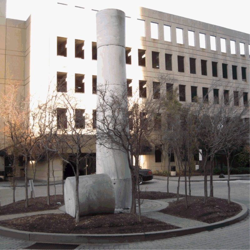
How to Retain Site Memory While Developing the Landscape
Winifred Lutz,
1990
* big
abstract
idea,
column from the Preston Retreat
* inscription:
The Preston Retreat was here once but now it is a circle for arrivals and departures.
* Courtyard Traffic Circle.
CityView Condominiums.
West side of 20th between Hamilton and Spring Garden.
* 39.962800,-75.171900 [map] [nearby]
* See also:
+freelibrary.org's Preston Retreat page
+winifredlutz.com
Neons for Buttonwood
Stephen Anotonakos,
1990
* big
abstract lines
* Roof.
South side of CityView Condominiums.
North side of Hamilton between 20th and 21st. Visible from the Parkway from 18th to 22nd..
* 39.962550,-75.171750 [map] [nearby]
* See also:
+stephenantonakos.com

Possible trip extension:Kelly Drive (6 blocks West on Hamilton and Pennsylvania)
See Also
+ccp.edu
+friendscentercorp.org
+baldwinparkphilly.org
+ldschurchtemples.com/philadelphia
+stjohnsphila.org